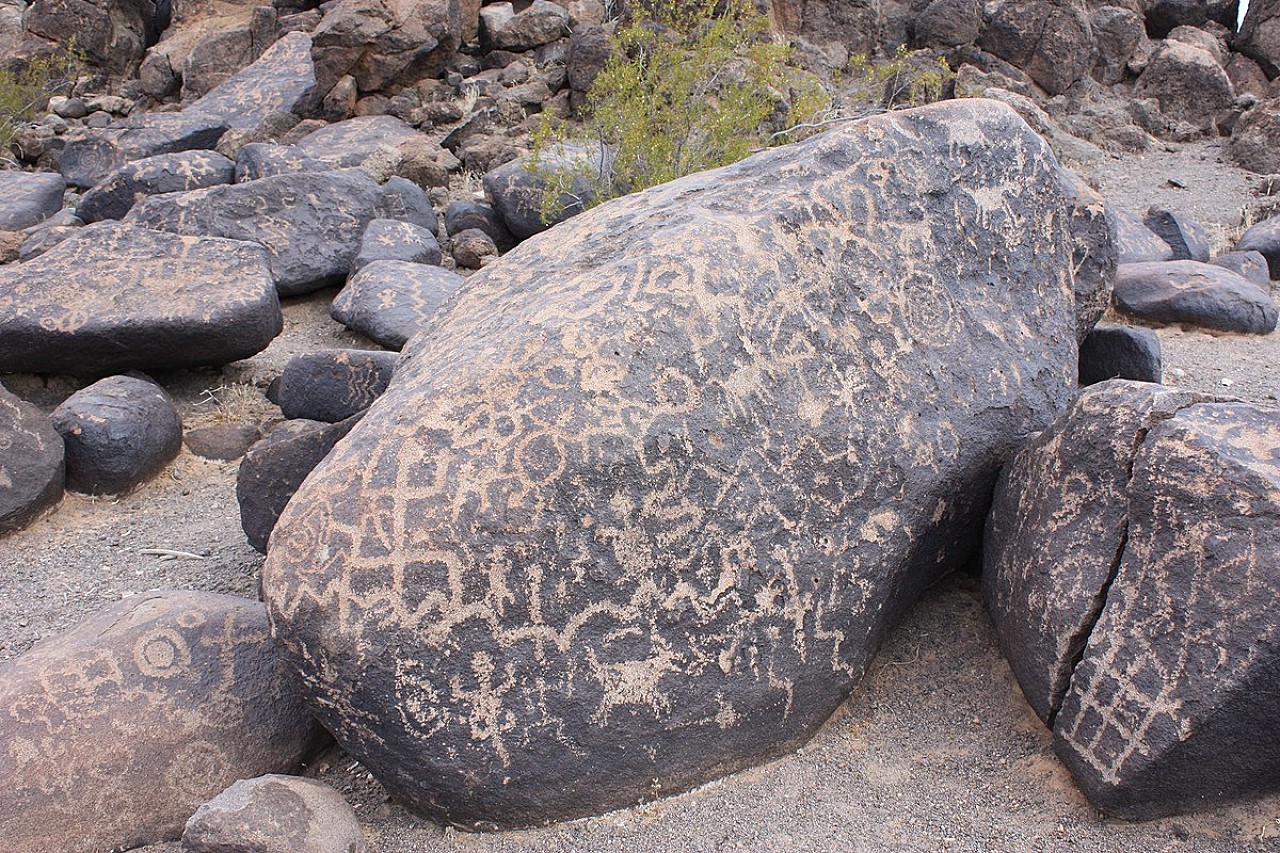


The Painted Rock Petroglyph Site is a collection of hundreds of ancient petroglyphs near the town of Theba, Arizona, listed on the National Register of Historic Places in 1977.
The Painted Rock Petroglyph Site and Campground is located approximately 90 miles southwest of Phoenix, Arizona. The site provides visitors the opportunity to view an ancient archaeological site containing hundreds of symbolic and artistic rock etchings, or "petroglyphs," produced centuries ago by prehistoric peoples. There are also inscriptions made by people who passed through during historic times. Several historic trails lie within the campground. The Juan Bautista de Anza National Historic Trail, the Butterfield Overland Stage Route and the Mormon Battalion Trail are three trails that played prominent roles in the history of Arizona and the American West. Visitors can learn about the site and historic trails through professional interpretive panels located on the site.
Overnight camping is allowed at the adjacent Painted Rock Petroglyph Campground. The campground has picnic tables, grills, steel fire rings, and a vault toilet. No potable water is available at the facility.
Located in the middle of the Sonoran Desert, Painted Rock Petroglyph Site is worth a stop on any Southern Arizona road trip. And since it’s just a short hop off the interstate, it makes a nice break and offers road trippers a chance to get some fresh air. And unlike some archeological sites, this one affords wheelchair-users and slow walkers an up-close-and-personal look at these ancient pieces of art. Best of all, since the Painted Rock Petroglyph Site is under the jurisdiction of the BLM, there’s no admission charge for folks who have an America The Beautiful Access Pass.
Petroglyphs Galore!!
The petroglyph site is located off of Interstate 8 near Gila Bend, Arizona. Take the Painted Rock Dam Road exit, and head north for about 11 miles, to Rocky Point Road. The site is just a half-mile down the road — you can’t miss it.
There’s wheelchair-accessible parking in a gravel area close to the trailhead, with level access over to the .3-mile loop trail. The hard-packed dirt trail circles a mound of boulders that are covered with more than 3,800 petroglyphs. It’s best to take the hard-packed dirt trail in a counter clockwise direction, as the largest concentration of petroglyphs are just 30 feet from the trailhead going that way. The oldest works date back some 1,400 years. It’s believed the petroglyphs were created by the Hohokam and Patayan peoples — ancestors of the Piipaash, O’odham, and Yavapai — who lived in nearby villages along the Gila River.
Some of the petroglyphs are easy to recognize, including those of humans, lizards, horses and deer; while others are a bit more abstract. Interpretive plaques along the way help visitors decipher what some of the images may mean. And keep a lookout for inscriptions made by others who passed through the area, which was close to the Mormon Battalion Trail, the Butterfield Overland Stage Route, and along the route of Juan Bautista de Anza’s expedition.
There’s also a dry campground located next to the petroglyphs, which is completely flat. And if you’d like to pack along a picnic lunch there are two shaded picnic areas and wheelchair-accessible vault toilets at the site. If you opt for a picnic lunch, pick the shelter closest to the parking lot, as it has the best pathway access. All in all, this ancient site makes a great educational — and accessible — Arizona side trip.

