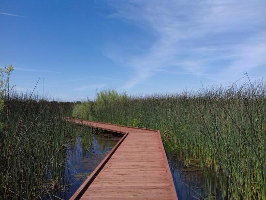


The Cosumnes River Preserve is a nature preserve of over 51,000 acres located 20 miles south of Sacramento, in the US state of California. The preserve protects a Central Valley remnant that once contained one of the largest expanses of oak tree savanna, riparian oak forest and wetland habitat in North America.
The Preserve is centered along the Cosumnes River, with opportunities for paddling, hiking, and nature viewing. The Preserve Visitor Center has an interpretive room so you can learn more about the history, flora, and fauna. Located just southwest of the Visitor Center is a boat launch so you can paddle the Cosumnes River and its sloughs. North of the Visitor Center is a trailhead with access to the Wetlands Walk and River Walk Trails.
Cosumnes River Preserve consists of over 10 miles of trails located around the main Visitor Center and at Rancho Seco Recreational Area. We encourage you to enjoy our trails from 8 am – 5 pm every day of the week! Pets, bicycles, and hunting are not allowed at the Preserve.
Cosumnes River is a beautiful, natural waterway and the central focus for the Preserve. Enjoy a scenic glide through the river’s sloughs and main channel, cruising along riparian forest, oak woodland and through wetlands teeming with wildlife. Click below to learn about hours, access maps, and guided paddles.
There are opportunities for wildlife and plant viewing all year! The Preserve is home to hundreds of species of flora and fauna. Because this special place is a safe sanctuary for so many native flora and fauna, we ask that you watch and explore with care.
The Cosumnes River Preserve consists of over 50,000 acres of wildlife habitat and agricultural lands owned by seven land-owning Partners. The Partners include The Nature Conservancy, Bureau of Land Management, California Department of Fish & Wildlife, Sacramento County Regional Parks, Department of Water Resources, Ducks Unlimited, and the California State Lands Commission. The Preserve is centered along the Cosumnes River, its floodplains and riparian habitat. This habitat is buffered by a variety of agricultural operations. The Preserve provides numerous social, economic, and recreational benefits to local communities and to people residing in the larger Sacramento and San Joaquin areas. The habitat supports wildlife, including birds that migrate throughout the Pacific Flyway.
Parking lots and trails open every day 8am – 5pm.
There’s plenty of accessible parking in the upper lot next to the visitor center, and ramped access to the front entrance. Inside you’ll find a number of interpretive exhibits, along with an information desk. The building itself overlooks a wetlands area, and there are also several accessible picnic tables on the deck.
f you’re traveling south on Interstate 5, take the Twin Cities exit, turn east and drive for a mile until you reach Franklin Boulevard. Turn south on Franklin Boulevard, drive 1.7 miles and look for the visitor center on your left. Northbound traffic should take the Walnut Grove -Thornton Road exit, turn east on Thornton Road and drive for about 2 miles. You’ll spot the visitor center on your right, just after you cross the Thornton-Franklin Bridge.
Wetlands Walk
Directly behind the visitor center, you’ll find the trailhead for the Wetlands Walk. This one-mile loop begins with a boardwalk though the wetlands, then continues on a paved level trail. There are several viewing areas along the way, and also a secluded accessible picnic table after the first boardwalk. Near the end of the loop, a half-mile boardwalk branches off to the right. It’s wide, level and nicely accessible, with a large viewing platform that overlooks the marsh. It’s an excellent place to spot Great Egrets, Northern Pintails, Red Winged Blackbirds, Turkey Vultures and — in season — Sandhill Cranes.
And if you just want to enjoy the boardwalk, but can’t manage the Wetlands Walk, there’s also accessible parking by the boardwalk next to an accessible pit toilet. This parking area is located north of the Visitor Center on the opposite side of Franklin Boulevard.
It should be noted that the rangers close the boardwalk at dusk, as it’s a favorite night roosting spot for the Sandhill Cranes. That said, the best time to visit this area is early evening, just before dusk, as it’s a beehive of activity then. Visitors are welcome to bring lawn chairs and just sit back and enjoy the show.
After the boardwalk, the Wetlands Walk winds past one final viewing platform and returns to the visitor center. Alternatively, if you’d just like to check out the last viewing platform, there’s also accessible parking and an accessible vault toilet in the lower parking lot at the visitor center. From there a level sidewalk leads across Franklin Boulevard to the platform.

