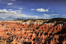


Cedar Breaks National Monument is a U.S. National Monument located in the U.S. state of Utah near Cedar City. Cedar Breaks is a natural amphitheater, stretching across 3 miles, with a depth of over 2,000 feet. The elevation of the rim of the amphitheater is over 10,000 feet above sea level.
Crowning the grand staircase, Cedar Breaks sits at over 10,000 feet and looks down into a half-mile deep geologic amphitheater. Come wander among timeless bristlecone pines, stand in lush meadows of wildflower, ponder crystal-clear night skies and experience the richness of our subalpine forest.
Cedar Breaks National Monument is also worth a visit while you’re in the area. In fact, you can do a very nice loop tour through the Dixie National Forest in just one day.
Begin your drive by heading east on Highway 14 from Cedar City. When you reach the 17-mile marker, slow down and look for the Bristlecone Pine Trail on your right. This half-mile loop is rated as wheelchair-accessible, and it may be doable for some people depending on its condition. There are some hard winters in this area, and most of the yearly trail damage comes from excess water and snow.
The hard-packed dirt trail leads though an ancient Bristlecone Pine Forest to a ramped viewing platform perched on the rim of the Markagunt Plateau. That said there are some ruts along the trail, but not so many that you can’t dodge them. The first portion of the trail usually has the worst damage, so if you can make it past that, you’re good to go.
As you continue on, turn left on Highway 148, and follow the signs to the Cedar Breaks Information Center. There’s plenty of accessible parking, with level access to the Visitor Center. Make sure and take time to admire the view from Point Supreme, which is next to the Visitor Center. There is level access out to viewpoint, which features a good overview of the 2,000-foot deep natural amphitheater.
And if you’ve packed along a lunch, the picnic area is located just up the road, on the right, near the campground. There’s accessible parking in the lot with level access over to the accessible picnic table.
As you continue along on Highway 148 you’ll get some great windshield views of the uplift and erosion on Markagunt Plateau. It’s filled with stone spires, columns, arches and canyons. Make sure and stop in at Sunset Overlook, which has paved parking and curb-cut access up to the viewing area, as well as Chesterman Ridge which has accessible parking and paved access out to the overlook. The latter is the highest point in the park — at 10,467 feet — and offers the most expansive view.
Continue along Highway 148, then take a right on Highway 143 to Panguitch. When you hit Highway 89, turn right and head through town. If you didn’t pack a picnic lunch, Panguitch is you best — well your only — lunch option. Continue along Highway 89, then reconnect to Highway 14, and head back to Cedar City. Along the way you’ll be treated to some lovely views of Navajo Lake on your left. Take your time and stop at the turnouts along the way to take it all in. It’s a very scenic end to this Dixie National Forest drive.

